6 – 18 May 2025
We are touring the North Coast 500 by car from the 6 – 18 May 2025.
The North Coast 500 is one of the world’s most beautiful road trips. It brings together a route of just over 500 miles (516 to be exact) of stunning coastal scenery starting and ending in Inverness. It explores one of Europe’s last wild places, the northern Highlands of Scotland.
A road trip where you can immerse yourself in a landscape where the soaring golden eagle is king; walk on deserted white-sand beaches and look out on turquoise seas; admire towering peaks, and vast moors peppered with castles while experiencing a landscape interwoven with tales of clan struggles and the brutality of the highland clearances.
ITINERARY
DAY 1 – TUESDAY 6 MAY
Logan Air flight from Manchester Airport to Inverness
Overnight at the Premier Inn, Inverness Centre, Millburn Road
DAY 2 – WEDNESDAY 7 MAY
Pick up hire car from Alamo Car Hire Desk, Inverness Airport
10.00 am Travel to Culloden Battlefield and Visitor Centre (15 minutes, 6.5 miles)
Look around the Visitor Centre. Lunch in the Visitor Centre Café. Guided Tour of the Battlefield.
https://www.nts.org.uk/visit/places/culloden
The Battle of Culloden took place on 16 April 1746; it was the last pitch battle to take place on British soil. A Jacobite army under Charles Edward Stuart, commonly known as Bonnie Prince Charlie or the Young Pretender, was decisively defeated by a British government force commanded by the Duke of Cumberland.
The term “Jacobite” originates from the Latin word “Jacobus,” which means “James,” and refers to supporters of the Stuart monarchs, particularly King James II and his descendants, who were exiled from the British throne
https://www.undiscoveredscotland.co.uk/inverness/culloden/index.html
2.00 pm Travel to Inverness (20 minutes, 8 miles)
One and half hour Walking Tour of Inverness, with ‘Walking Tours In Inverness’
Inverness is the capital of the Highlands situated where the River Ness flows into the Moray Firth. It can trace its history back to the Picts in 400BC. It has been a natural focus for lines of communication to and through the highlands for most of the last two thousand years.
https://www.undiscoveredscotland.co.uk/inverness/inverness/index.html
Dinner and overnight at North Kessock Hotel (6 miles, 20 minutes)
https://www.northkessockhotel.co.uk/
DAY 3 – THURSDAY 8 MAY
9.30 am travel to Cromarty (35 minutes, 20 miles)
Cromarty is considered the best-preserved example of an 18th-century town in Scotland and one of the prettiest villages. Its narrow, winding side streets are lined with cute fishermen’s cottages and handsome Georgian houses.
https://www.undiscoveredscotland.co.uk/cromarty/cromarty/index.html
Lunch at Crofters Cafe, Rosemarkie (15 minutes, 8.7 miles) followed by a walk on the beach.
2.00 pm Travel to Fairy Glen Falls (5 minutes)
Fairy Glen Falls is a delightful 1.5 mile walk through a broadleaf woodland to two small waterfalls. They are not remarkable for their height but overflowing with charm. It is a 30-minute walk each way.
As for the fairies, it’s said that long ago, children would decorate the spring near the falls with wildflowers as a tribute to the fairies to keep the waters clean for drinking and washing.
The path is uneven in places and can be muddy and slippery.
https://www.livebreathescotland.com/fairy-glen-falls-rosemarkie
3.15 pm travel to Tarbat Ness Lighthouse (1 hour 10 minutes, 46 miles)
In November 1826, sixteen vessels were lost in a storm in the Moray Firth. This led to the building of Tarbat Ness Lighthouse on the Northwest Tip of the Tarbat Peninsula, which reaches out into the North Sea.
The lighthouse was engineered by Robert Stephenson. The lighthouse started working on 26 January 1830. It’s the third-tallest lighthouse in Scotland. It cost £9,361 to build.
According to Highland folklore, the lighthouse site was used as a meeting place for witches’ covens; before that, it was a Roman Fort.
From the lighthouse car park, go through a green metal gate, which takes you around the back of the lighthouse to a cove.
Also, if you go to the far end of the car park, you will see a second gate, which takes you to another isolated cove. If the weather allows, you can see Dunroben Castel across the North Sea.
Dinner and overnight at The Oystercatcher B&B, Portmahomack (10 minutes, 3 miles)
https://www.the-oystercatcher.co.uk
The Oystercatcher is renowned for its high-quality food offering and massive choice of dishes for breakfast!!
Portmahomack is a pretty seaside village on the shores of the Dornoch Firth. Very few people live in the village nowadays, but in the eighth century AD, it was the heartland of Picts before Viking raids drove them out.
Portmahomack grew as a fishing village. At its peak in the 1830s, it was home to over 100 fishing boats, supporting a large onshore fish-curing industry.
Today, its picture-postcard harbour remains home to several small fishing boats. But it is also popular with leisure craft and has become a pleasant resort complete with a broad sandy bay edged at low water with rock pools.
https://www.undiscoveredscotland.co.uk/portmahomack/portmahomack/index.html
DAY 4 – FRIDAY 9 MAY
9.30 am Walk on Portmahomack beach
9.55 am Travel to the Tarbat Discovery Centre (5 minutes).
The Tarbat Discovery Centre is on the grounds of the ancient church of St Colman. The centre displays works of art created in stone by the Picts a group of people who lived in Northern and Eastern Scotland in the middle ages 300AD to 900AD, more than 1,200 years ago.
11.00 Travel to the Big Burn Walk, Golspie (27 miles, 45 minutes)
The story of Golspie is largely the story of the Dukes of Sutherland and their predecessors, the Earls of Sutherland.
As you drive into Golspie, we will see the Sutherland Monument on the left at the top of Ben Bhraggie. This 100-foot-high statue is of the first Duke of Sutherland, the landowner who oversaw the brutal eviction of 15,000 crofters from his million-acre estate during the Highland Clearances.
The Highland Clearances lasted from 1760 to 1860. Approximately 140,000 highland farmers were forced off their land that had been inhabited by generations before them, with brute force, changing the way of life and landscape irrevocably. Some of those forced from their land emigrated, others resettled in new villages along the coast, and others were forced into isolated small crofts. The clearances occurred because the large landowners discovered they could make more money by grazing sheep on the land than they could from crofter’s rents.
Video about the inhumanity of the Highland Clearances
Highland Clearances and The Duke of Sutherland
11.45 am Big Burn Walk, Golspie
This is a 20-minute spectacular walk that follows the Golspie Burn up a forested gorge. Paths cross several footbridges, a skating pond, and many waterfalls. The walk culminates in a spectacular huge waterfall with a specially built viewing platform. It takes around 40 minutes to walk there and back.
From the car park, pass through the entrance to the right, not the left. The path can be muddy.
https://www.livebreathescotland.com/big-burn-walk-golspie-sutherland
Lunch at Linda’s Café, Roslyn Street, Brora Village (10 minutes, 5.3 miles)
Brora is an interesting mix of a lovely coastal resort with a gorgeous beach and an industrial town. Until the 1970s, it was home to Scotland’s most northerly coal mine. Perhaps it is best known for its whisky and the attractiveness of its small harbour.
https://www.undiscoveredscotland.co.uk/brora/brora/index.html
2.00 pm Travel to Timespan Heritage Museum, Helmsdale (17 minutes, 11.3 miles)
Helmsdale was founded in the nineteenth century to house people evicted from the clearances.
Timespan Heritage Museum tells the story of Pictish mythology, Viking Raids, the highland clearances, the last wolf shot in Sutherland in 1700, the burning of the last witch in Sutherland in 1727, the Kildonan 1869 Gold Rush and the boom and bust of the herring fishing industry.
4.00 pm Travel to Camster Cairns (40 minutes, 28 miles)
The Grey Cairns of Camster are two large Neolithic Chambered Cairns. There is a Long Cairn and a Round Cairn with central burial chambers accessed through narrow passages from the outside. The Long Cairn originally consisted of two round Cairns but at some point, it was converted into one Long Cairn. These two enormous, reconstructed burial chambers, originally built 5,000 years ago with corbelled dry-stone roofs, are among the oldest structures in Scotland. Cairns have been and are used for a wide variety of purposes. In prehistory, they were raised as markers and burial monuments. You can crawl into them, but the entrances are narrow with low roofs.
From the car park, walk on raised wooden walkways to the cairns. Beware, the land around the boards is boggy!! Also the area is known for its midges so put on plenty of midge repellent.
https://www.undiscoveredscotland.co.uk/lybster/greycairns/index.html
Dinner and overnight at Mackays Hotel, Wick (25 minutes, 18 miles)
https://www.mackayshotel.co.uk
Mackays Hotel, is a wedge shaped building which reaches its narrowest point nearest the bridge. This end of the building stretches the full length of Ebenezer Place, which appears in the Guinness Book of Records as the world’s shortest street at 2.06m or 6ft 9in in length.
Founded by the Vikings Wick sits astride the River Wick. In the mid-nineteenth century, Wick was the busiest herring port in Europe, with more than 1,100 boats exporting fish to Russia, Scandinavia, and the West Indian slave plantations.
https://www.undiscoveredscotland.co.uk/wick/wick/index.html
DAY 5 – SATURDAY 10 MAY
9.00 am Travel to Caithness Sea Coast Adventures, Wick
90-minute Rib Boat Tour Coastal Adventure, heading south around the east Caithness coastline. See castles, sea caves and stacks, wildlife and harbours.
One of the places the rib boat visits is Whaligoe Steps, Lybster. There are two ways to get to the Whaligoe Steps: by the rib and looking at it from the sea or by walking down 365 narrow steps that descend to a naturally formed harbour between two 250-foot-high sea cliffs. The natural harbour at the foot of the steps has been a long-standing landing point for herring, salmon, whitefish, and shellfish.
https://www.undiscoveredscotland.co.uk/lybster/whaligoesteps/index.html
11.30 am Visit Wick Heritage Centre and Museum, Putteneytown
The Museum houses several furnished rooms and exhibitions that portray Wick’s herring fishing heritage. Displays highlight working life, community life, and family life across the period and contain an array of authentic items, including household furnishings, ranging from a traditional box bed to authentic Caithness chairs. It also features a kippering kiln, a cooperage, an art gallery, and the renowned Johnston Photographic Collection, which showcases Wick’s 115-year history, spanning a period when Wick was the herring capital of Europe. There is also a working lighthouse and a harbour setting. As you enter the building, a team of dedicated volunteer guides, each with their own historical knowledge, awaits to explain the many aspects of life during the heyday of herring fishing.
Lunch at Wickers World Café, 21 Harbour Quay, Wick
2.15 pm Travel to Castle Sinclair Girnigoe (5 miles, 15 min)
Castle Sinclair Girnigoe is located about 3 miles north of Wick on the east coast of Caithness, Scotland. It is considered to be one of the earliest seats of Clan Sinclair. It comprises the ruins of two castles: the 15th-century Castle Girnigoe; and the early 17th-century Castle Sinclair. It is the only castle in Scotland listed by the World Monuments Fund.
https://www.undiscoveredscotland.co.uk/wick/castlesinclairgirnigoe/index.html
3.30 pm Travel to John O’Groats (20 miles, 35 minutes)
https://www.undiscoveredscotland.co.uk/johnogroats/johnogroats/index.html
4.30pm Travel to Duncansby Head (2.3 miles, 7 minutes)
Duncansby Head is the most northeasterly part of the Scottish and British mainland. It probably exceeds John O’Groats’ distance from Land’s End by a good mile or two. The point is marked by the Duncansby lighthouse, which was built in 1924. Look North for views over Orkney, and west to John O’Groats and Dunnet Head.
Geo of Sclaites: From the lighthouse car park, follow the cliff-top path to your right. You will first come to the Geo of Sclaites, a huge cleft bitten deeply into the cliffs. It also brings you to the sound of its vast numbers of feathered inhabitants and a smell that would convince anyone who needed convincing that seagulls eat fish.
Stacks of Duncansby: A little further across the clifftop fields, you come to the stunning view south to Thirle Door and the Stacks of Duncansby.
The first is a rocky arch, and the second is a group of large, jagged sea stacks. The birdlife here is prolific, with fulmars, razorbills, puffins, guillemots, and Kittiwakes flitting in large numbers at these imposing sea stacks.
https://www.undiscoveredscotland.co.uk/johnogroats/duncansbyhead/index.html
Dinner and overnight at John O’Groats Guest House (10 minutes, 2.6 miles)
https://www.johnogroatsguesthouse.com
DAY 6 – SUNDAY 11 MAY
9.30 am Travel to Dunnet Head (30 minutes, 15 miles)
Dunnet Head is the most northerly point of mainland Britain. It is 2.35 miles further North than John O’Groats. It overlooks the Pentland Firth.
It can be very windy, so be careful when opening the car door. When following the cliff paths extreme care is needed, as there is a sheer drop to the sea!!
From the car park, take a path towards the seabird cliff. A solid wall stands between you and the edge, so it’s a good spot to view the cliffs and many species of birds, including guillemots, razorbills, fulmars, and puffins.
Another bumpy trail rises further up the hill from the car park to the summit viewpoint. From here, you can see the Duncasby Stacks to the East, Cape Wrath to the West and North to Orkney.
Also in this area are buildings from the Second World War. In addition to being a radar station, the uninterrupted view from Dunnet Head was ideal for monitoring the approaches to the Royal Navy base at Scapa Flow.
Dunnet Head Lighthouse is 20m (60ft) high and is perched on a 85m (279 feet) sheer cliff face. The lighthouse was built in 1831 by Robert Stevenson. In 1989, the lighthouse became automated. The light operates using sensors and is remotely monitored by the Northern Lighthouse Board.
https://www.undiscoveredscotland.co.uk/dunnet/dunnet/index.html
10:30 a.m. Travel to Strathy Bay Beach (One hour. 35 miles)
As we head west, the rich farmland of the East Coast is replaced by stark heathland.
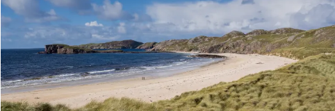
Strathy Bay is a remote, stunning 1.5-mile-wide sandy beach with clear blue waters that stretch out into the Atlantic Ocean. The bay is also home to numerous caves along the coast and several sea stacks. The beach is popular for surfing.
Lunch at The Store Café, Bettyhill (20 minutes, 11miles)
Bettyhill is a relatively recent creation. The original village in the area was Farr, which is now a crofting settlement a mile northeast of Bettyhill. Between 1811 and 1815, 15,000 people were cleared from the land by the Duke and Duchess of Sutherland. The Countess of Sutherland, in a move unusual for the time, had a resettlement village built near the coast. This she named after herself Bettyhill.
2 pm Travel to Coldbackie Beach (25 minutes, 10.5 miles)
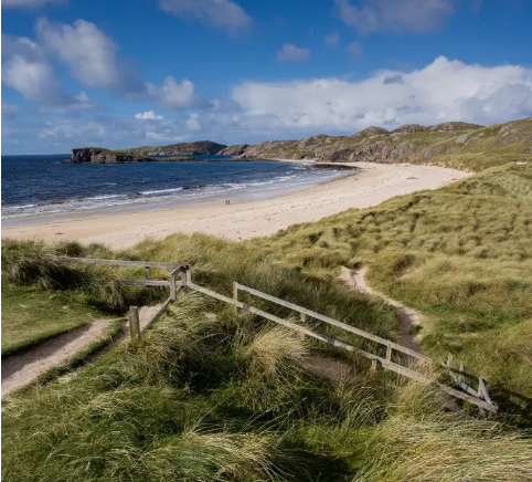
Coldbackie Beach has miles of stunning white sands and beautiful crystal-clear turquoise waters. It offers views of the Rabbit Islands and the Orkneys. Often, the beach is entirely deserted and is the perfect place to spend some quiet time. It is a popular spot for surfers.
3.30pm Leave travel to Ard Neackie Lime Kilns (25 minutes, 13 miles)
Ard Neakie is a craggy peninsula jutting out into Loch Eriboll connected to the mainland by a thin band of sand. Sitting on Ard Neakie are four excellently preserved lime kilns. They were built around the 1870s and were used for producing lime, which was then transported in ships to be sold and used in farming. Limestone brought from a nearby quarry would be loaded into the kilns and then burned with coal, coke, or peat, which was transported by ship. You can also see the ruins of a boathouse and inn. The kilns symbolise a time in history when people relied on the sea for trade and resources.
Loch Eriboll, which is one of the deepest sea lochs in Scotland, has a fascinating history. It was here that the 33 surviving German U-boats formally surrendered at the end of the Second World War.
https://www.undiscoveredscotland.co.uk/durness/locheriboll/index.html
Dinner and overnight at Wild Orchard Guest house, Durness (19 miles, 45 minutes)
https://www.wildorchidguesthouse.co.uk
DAY 7 – MONDAY 12 MAY
9.00 am – Travel to Durness Beach (5 minutes, half a mile)
Beautiful beach, crystal clear sea and white sands
10.00 am – Travel to Balnakeil Craft Village (5 minutes, one mile)
balnakeilcraftvillage.weebly.com
Units to visit:
Mudness Ceramics – Individually designed pottery and hand-painted silk scarves
Balnakeil Glass – Stained and fused glass made into glass beads and unique jewellery
Cast Off Crafts – Uses driftwood, shells etc and works them into decorative things
Cocoa Mountain – Chocolatier selling handmade chocolates also sells coffee and Hot Chocolate
11.00 am Travel to Smoo Cave (6 minutes 1.7 miles)
Smoo is Norwegian for “cave” and dates back to the 12th or 13th century. It’s a gaping hole in a limestone cliff created by the sea. The main chamber is accessible via steps from the car park. The approach is imposing, with an entrance 50 feet high, 130 feet wide and 200 feet (61 meters) long. You are virtually walking towards a giant mouth. Inside the cave, a covered wooden pathway and bridge lead the visitor to a magnificent cascade that falls 25 meters into an 8-meter-deep pool. From there, you can walk across a wooden walkway to the Lake (or waterfall). Visiting this part of the cave is free of charge.
Depending on the weather, you can also take a fantastic thirty-minute trip by rubber dinghy (operating on demand) to explore two additional caverns. This involves climbing down some ladders and walking over rocky and uneven ground. You will need good footwear and cash (£ 15 per person), as they don’t accept credit cards.
Call the Smoo Cave weather message line (01971 511 492) anytime from 9.30 am on the day to see if dingy tours are taking place as even a relatively small amount of rain can cause the cave to flood. Unfortunately, you cannot pre-book.
Lunch at Crofters Kitchen, Scourie (45 minutes, 27 miles)
https://www.crofterskitchen.com
Crofters Kitchen is a food waggon situated on a croft by the beach. It offers fresh sea food sourced straight from fishing boats and produce sourced from local farms.
2.00 pm Travel to Wailing Widow Falls (20 minutes, 13 miles)
The Wailing Widow Falls is one of Scotland’s most stunning waterfalls. It has a fifty-foot drop down from Loch na Gainmhich crashing into a narrow canyon at the bottom.
It is claimed that it gets its name from a deer hunter who fell over the top of the falls whilst hunting on a rainy day. Filled with grief, his mother threw herself from the same spot the following morning.
From the car park (which may be blocked with boulders) see a stoney, rough, uneven path with some small rocks to walk over. This runs along a small river and takes you to the base of the falls a 20-minute walk. You can’t see the falls from the car park, once the river goes around a big bend you will then see the falls.
The path can be slippery, so care is needed especially when walking over the rocks. Good footwear essential.
3.15pm Travel to Highland Stoneware, Lochinver (25 minutes, 15 miles)
Highland Stoneware have been making pottery in Lochinver, since 1974. Each piece is handmade and freehand painted by exceptionally skilled craftspeople. Visitors are welcome to look round the pottery workshop and watch whatever processes are going on and visit the shop where you can buy items.
Overnight at Ardmore House B&B, Lochinver (7 minutes, 2.3 miles)
https://ardmorehousebnb.co.uk/
Places to eat:
Peets https://www.peets.co.uk
Delilah’s https://www.delilahs.co.uk
Lochinver is a fishing port and the largest settlement on the West coast of Scotland north of Ullapool. It is situated at the head of the sea loch Loch Inver. Its harbour is the busiest in the Highland Council area. The port is used by European fishermen primarily from Spain and France, many landing catches at the large fish market. On the main street see the striking war memorial and Church of Scotland.
https://www.undiscoveredscotland.co.uk/lochinver/lochinver/index.html
DAY 8 – TUESDAY 13 MAY
9.30 am Travel to Achmelvich Beach (2.5 miles, 10 minutes)
One of the best beaches in the UK. It’s a great place for wildlife spotting, with a range of birds, porpoises, dolphins, and even minke whales sometimes visible from the shore. Just off the beach, you will see Hermits Castle, the smallest castle in Europe.
https://www.undiscoveredscotland.co.uk/lochinver/achmelvich/index.html
11am Coffee at An Cala Café and Bunkhouse, Culag Park, Lochinver (5 miles 15 minutes)
An Cala Café and Bunkhouse is housed in what was the Fishermen’s Mission.
12 noon Wildlife Boat Tour (return 1.30 pm) with North Coast Sea Tours
Discover wildlife and visit the seal colonies. Things we may see: porpoises, dolphins, basking sharks, whales, and lots of species of seabirds including sea eagles. We will also see the most amazing scenery with fantastic views of Assynt’s stunning mountains as well as beautiful beaches and the amazing Split Rock.
Lunch at Lochinver Larder, Main Street, Lochinver
https://www.lochinverlarder.com
The Lochinver Larder is world famous for its pies.
2.45 pm Meet up with Griogair Macallein a seanchaí (traditional Gaelic storyteller) and poet.
Taken on a guided story walk with Griogair Macellein an award-winning storyteller, folklorist and poet. Explore the Assynt landscape to reveal some of the stories hiding in the bracken, roaming the riverbanks, and lurking in the lochans.
Take part in a Hand Fasting ceremony. “The gentle ‘binding’ of each of our hands by the wrist with ribbons, cords or any meaningful material chosen by the celebrants in an agreement and public declaration of mutual love and the beginning of creating a life together – initially for ‘a year and a day’”.
Overnight Ardmore House B&B, 80 Torbreck, Lochinver (2.5 miles, 10 minutes).
https://ardmorehousebnb.co.uk/
Places to eat:
Peets https://www.peets.co.uk
Delilah’s https://www.delilahs.co.uk
DAY 9 – WEDNESDAY 14 MAY
9.00 am Travel to Ullapool (one hour, 37 miles)
As we leave Lochinver see the distinct ‘Suilven ‘(2,398 ft) on our right, a sandstone dome/mountain in a wilderness landscape of moorland bogs.
https://www.undiscoveredscotland.co.uk/lochinver/suilven/index.html
11 am Visit Ullapool Museum & Visitor Centre, West Argyle Street.
Discover the social history of Ullapool and Loch Broom. Get an insight into crofting, fishing, and emigration. During the Clearances, Ullapool was one of the ports through which evicted crofters left to start new lives abroad.
https://www.undiscoveredscotland.co.uk/ullapool/ullapoolmuseum/index.html
Ullapool is a small, picturesque fishing village situated on the shores of Loch Broom. The British Fisheries Society founded the village at the height of the herring boom in 1788. By the 1830s, due to overfishing, the boom had come to an end. In the 1900s, distant fishing fleets from eastern Scotland and beyond discovered Ullapool’s benefits. Since then, the fortunes of the Scottish fishing fleet have ebbed and flowed, but fishing has remained at the heart of the town’s economy. The village is also the terminus for the ferry to Stornoway.
https://www.undiscoveredscotland.co.uk/ullapool/ullapool/index.html
Lunch at the Seafood Shack, a fresh seafood truck, 9 West Argyle St, Ullapool
Situated down by the side of Ullapool Outdoors shop.
1.30 pm Travel to Corrieshalloch Gorge and Nature Reserve (13 miles, 20 minutes) (Car Park £5)
https://www.nts.org.uk/visit/places/corrieshalloch-gorge
Corrieshalloch Gorge is a spectacularly deep mile-long box canyon through which the River Droma descends into Loch Broom via the spectacular 160ft Falls of Measach.
You have to cross a wobbly suspension bridge spanning the gorge 197ft below to get to the falls!! The number of visitors allowed on the bridge is limited to six at any one time.
From the bridge, you follow a path that leads to a viewing platform cantilevered halfway over the gorge from the north side. It offers stupendous views of the Falls of Measach to the east: but provides another stern test for those with vertigo.
https://www.undiscoveredscotland.co.uk/ullapool/corrieshalloch/index.html
2.30 pm Travel to The Old Curing Station, Dry Island, Badachro (50 miles, one and half hours)
Dry Island is a private island linked to the mainland by a floating bridge which can get wet and slippery, so need to wear shoes with a good grip. Also need a torch for navigating the path from the car park to the island in the evening.
The Old Curing Station is a class B Listed building situated on Dry Island. The building dates back to 1841. The self-contained ground floor apartment sleeps 2 adults.
The owner of the Old Curring Station and Dry Island, Ian McWhinney, his wife Jess and children live upstairs.
The Old Curring Station is self-catering accommodation. Shared decking area and picnic bench overlooking Dry Island pier, 5 metres from the sea. Private hot tub with loch views
Overnight at The Old Curing Station
Dinner at The Badachro Inn, Gairloch (One mile, 5 minutes)
DAY 10 – THURSDAY 15 MAY
9.30am Go out with Ian McWhinney in his fishing boat on a Shellfish Safari
The 90-minute trip includes seeing langoustine creels pots, crab pots and squat lobster pots pulled from the deep.
Then we go back to The Old Curring Station, where Jess, Ian’s wife cooks what we have caught for lunch
Afternoon free. Ideas for things to do:
Just relax go in the hot tub
Gairloch Harbour – https://www.undiscoveredscotland.co.uk/gairloch/charlestown/index.html
Gairloch Museum – https://www.gairlochmuseum.org/museum-from-home
Gale Centre, Community Hub, Café and tourist information
Big Sands Beach (4 miles, 10 minutes from Gairloch)
www.visitscotland.com/info/see-do/big-sand-beach-p2556001
https://www.undiscoveredscotland.co.uk/gairloch/gairloch/index.html
Dinner at The Badachro Inn, Gairloch (One mile, 5 minutes)
DAY 11 – FRIDAY 16 MAY
9.30 am Travel to Beinn Eighe National Nature Reserve (20 miles, 35 minutes)
Beinn Eighe National Nature Reserve was set up in 1951 and was the first nature reserve in the UK. It has some of the oldest Caledonian woodland in Scotland. Golden eagles and ravens soar above its mountain peaks and the ancient pinewoods are home to Scotland’s most secretive wildlife, pine martens, wild cats and the unique Scottish crossbills.
First, visit the Beinn Eighe Visitor Centre on the A832. Collect leaflets covering the walking trails.
Then travel to Coille na Glass-Leitir Trails car park, which is 2.5 kilometres west of the visitor centre on the A832.
Take the mile-long Woodland Walk through ancient Caledonian pinewoods, which takes around one hour.
Lunch at Nanny’s Café, Shieldaig (37 miles, one hour)
https://www.nannysshieldaig.co.uk
Shieldaig sits on the shore of Loch Shieldaig (sea loch). It would be a finalist in any “most picturesque village in Scotland” competition. Its location is truly superb, on the edge of Loch Shieldaig, an offshoot of Loch Torridon. Opposite the village is Shieldaig island which is a bird sanctuary owned by the National Trust.
Shieldaig was established in 1800. Its purpose was to attract families to take up fishing catching herring for a living; and, in the process, to help build up a stock of trained seamen who could be called upon by the Royal Navy during the Napoleonic wars. Today local employment is in fishing catching crabs, scallops and Nephrops which are mini lobsters but referred to locally as prawns. There are also salmon farms in the area.
2.30pm Travel to Fort Augustus (2 hours, 84 miles)
Fort Augustus is a small, picturesque Highland village situated at the Southwest end of Loch Ness where it meets the Caledonian Canal. The village has a population of around 646.
Fort Augustus is named after the 17th century fort named after the youngest son of King George, William Augustus the Duke of Cumberland. He became known as The “Butcher of Cumberland” who was responsible for repressing the Highlands and destroying the ancient clan system after the defeat of the 1745 Jacobite uprising at Culloden.
https://www.scotlandswild.com/fort-augustus
Dinner at Beaufort House Pizza, Station Road, Fort Augustus
https://www.facebook.com/beauforthouselochness
Overnight Rose Cottage B&B
DAY 12 – SATURDAY 17 MAY
9.30am Day out in Fort Augustus.
Morning
Visit the Caledonian Canal Heritage Centre – details the history of the canal
Visit the Mill shop
Visit Loch Ness Viewpoint
Visit the Clansman Centre, PH32 4BD (Book a show)
Walk up the canal watch the boats navigate the locks
11.00am at brunch at DelightfulNess, Canalside, PH32 4AU
https://www.facebook.com/p/DelightfulNess-100083203058515/?locale=en_GB
Small deli / Café
12.00 Travel to Loch Ness Rib rides, Dores Bay next to Dores Inn
https://lochnessribrides.com/our-tours/
2pm One and half hour Loch Ness rib boat trip with Loch Ness Rib Rides
3.45 pm Travel to Inverness Airport (45 miles, 75 minutes). Drop the car off
Overnight Premier Inn Inverness Centre, Millburn Road, (8 miles from airport, 15 minutes)
DAY 13 – SUNDAY 18 MAY
Logan Air flight to Manchester Airport
